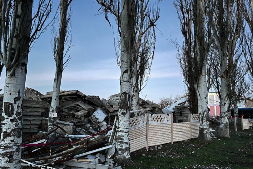
The village of Pervomaiske in Mykolaiv Oblast is currently the focus of the HOPE HOME – НАДІЯ project, a pilot project for the ecological reconstruction of Ukraine. In the HopeHome seminar, students from the TU Berlin were involved in mapping the site for the first time in order to establish a basis for continuing the project and simplifying communication between project partners.
Село Первомайське в Миколаївській області наразі є центром проєкту HOPE HOME – НАДІЯ, пілотного проєкту з екологічної реконструкції України. У межах семінару HopeHome студенти Технічного університету Берліна вперше брали участь у картографуванні місцевості, щоб створити основу для подальшого розвитку проєкту та спростити комунікацію між партнерами.
There was hardly any geographical data about Pervomaiske before the seminar began. Online providers such as Google Maps, Openstreetmaps and various GIS programmes and datasets had large gaps in terms of infrastructure and building stock. For further steps of the project, it was urgently necessary to have more data, on the one hand in order to be able to carry out an inventory and needs assessment at all and on the other hand in terms of communication with the residents and the various project partners. The students Bela Mohr, Karim Touhtouh and Malte Heesen (Bachelor) worked on this project in a three-week window.
До початку семінару майже не було географічних даних про Первомайське. Онлайн-платформи, такі як Google Maps, OpenStreetMap, а також різні ГІС-програми та набори даних, мали значні прогалини щодо інфраструктури та забудови. Для подальших етапів проєкту було вкрай необхідно зібрати більше даних: по-перше, для проведення інвентаризації та оцінки потреб, а по-друге, для покращення комунікації з місцевими жителями та різними партнерами проєкту. Студенти Бела Мор, Карім Тухтух і Мальте Хізен (бакалаврат) працювали над цим проєктом упродовж трьох тижнів.
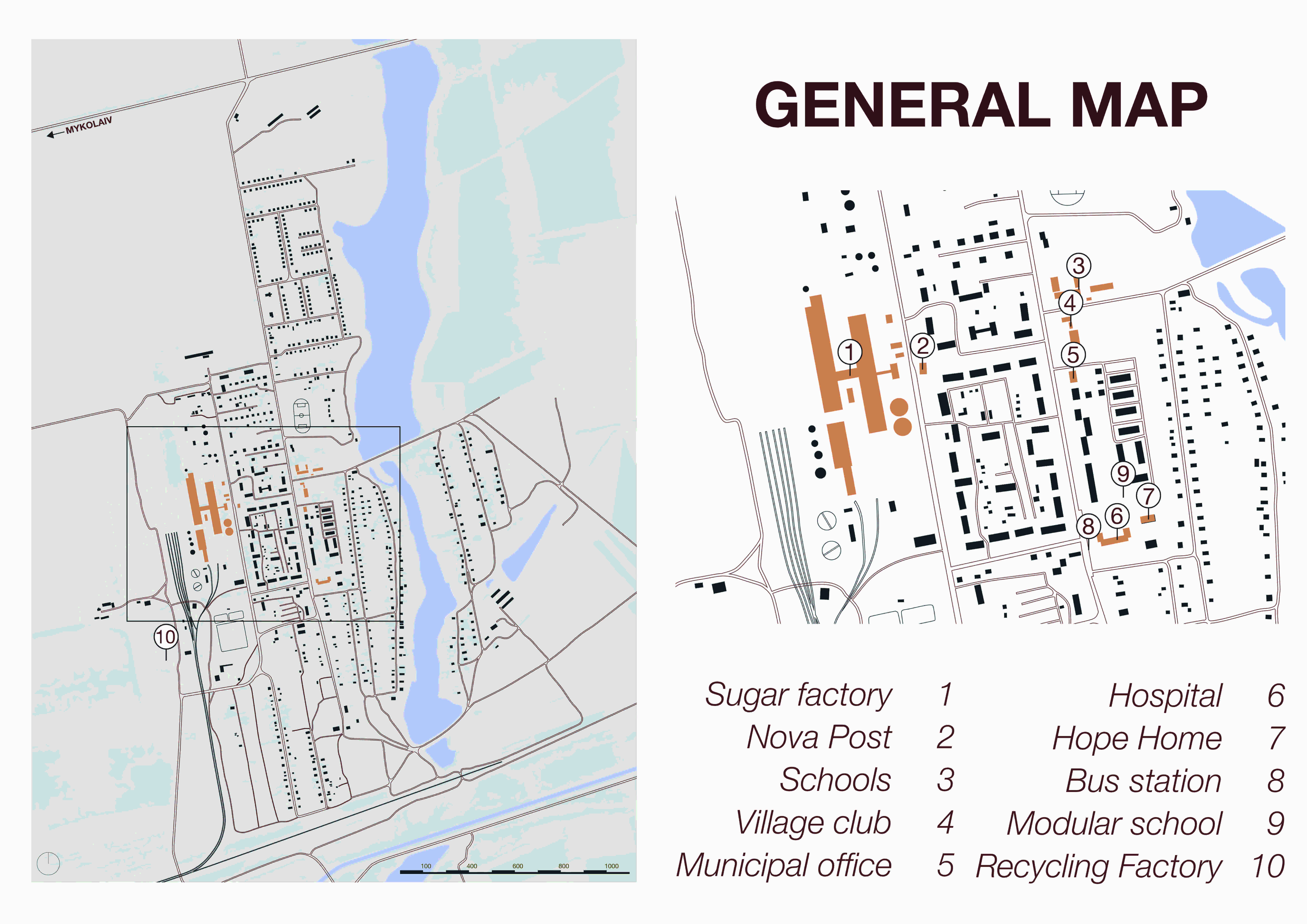
Першим кроком стало базове 2D-картографування всієї території. Після дослідження різних геопорталів студенти дійшли висновку, що буде простіше створити нову карту з нуля, відмовившись від наявних даних, оскільки вони були надто фрагментарними. Тому для відтворення інфраструктури та будівель були використані супутникові знімки. Найважливіші будівлі в цьому районі були виділені окремо.
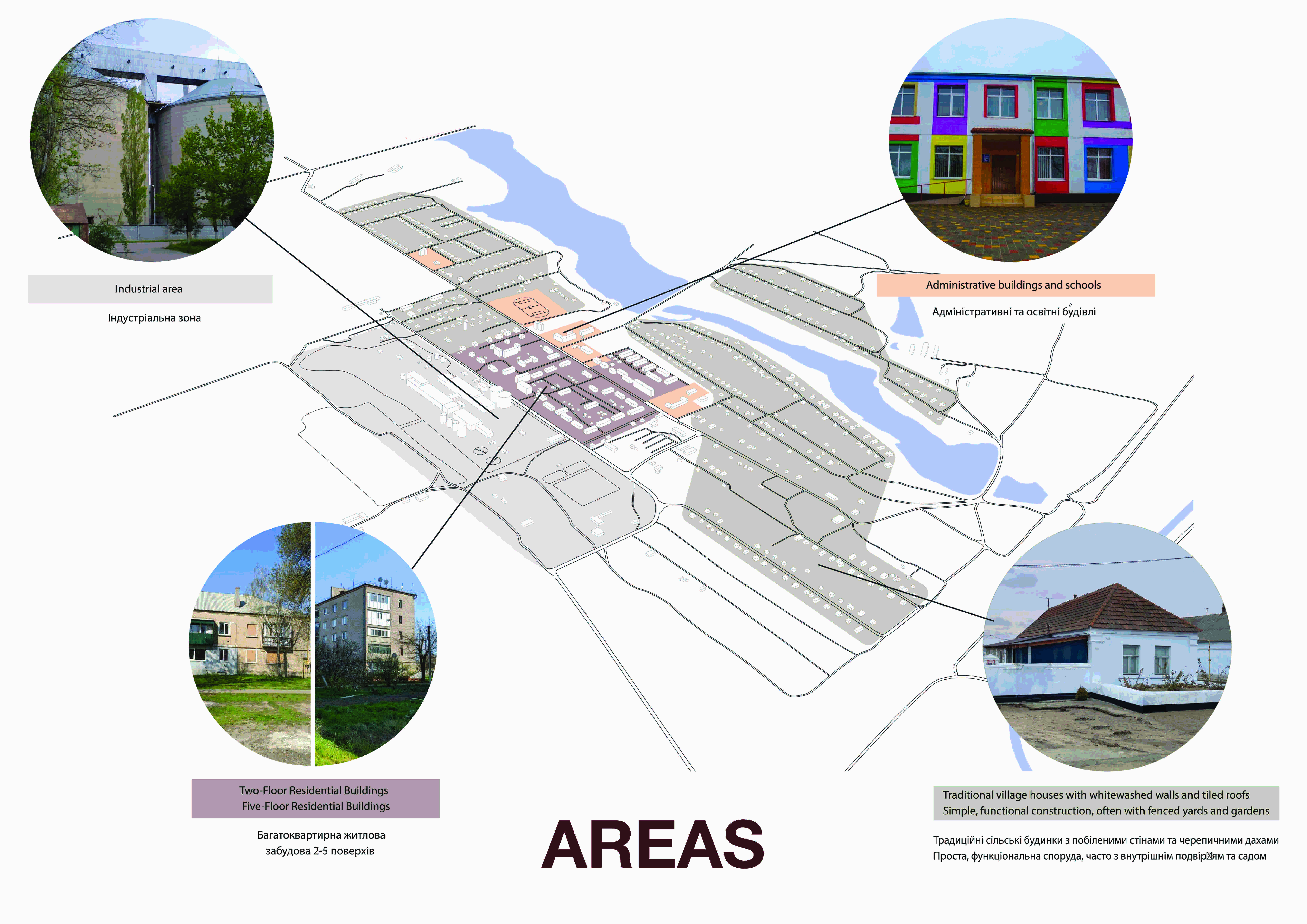
Крім того, студенти створили 3D-візуалізацію території. Вона використовувалася для наочного представлення різних типів будівель і зон населеного пункту. Було визначено чотири основні категорії: промислові зони, традиційні приватні будинки, щільні багатоквартирні будинки та адміністративні будівлі (включно зі школами).
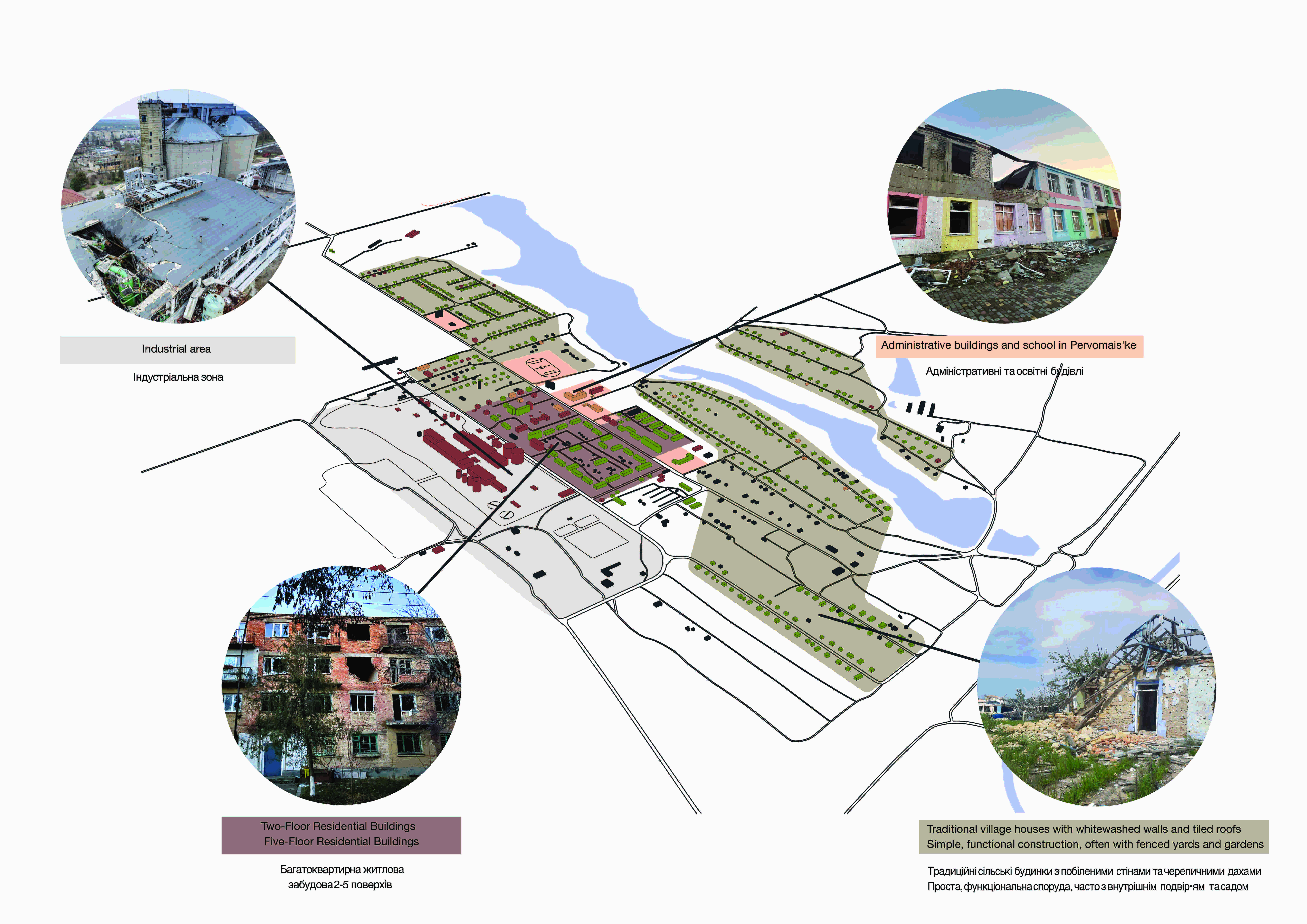
На наступному етапі першу 2D-карту було передано громаді села, яка позначила на ній стан будівель. На основі цих даних була розроблена карта ступеня руйнувань, у якій за допомогою кольорового кодування можна визначити різні категорії: зруйновані будівлі, що перебувають у процесі відновлення, частково зруйновані споруди, які також ремонтуються (наприклад, із пошкодженими вікнами чи дахами), будівлі, що підлягають знесенню, а також неушкоджені об’єкти. Ця карта стала важливим інструментом для подальшого планування відбудови.
The 3D visualisation of the destruction provides a better overview of the different areas. Images of the destroyed buildings have also been added here, showing the extent of the destruction compared to the intact buildings in the first 3D map.
3D-візуалізація руйнувань дає кращий огляд різних зон. Тут також були додані зображення зруйнованих будівель, які демонструють масштаби руйнувань у порівнянні з неушкодженими будівлями на першій 3D-карті.
How to Use Open-Street-Map
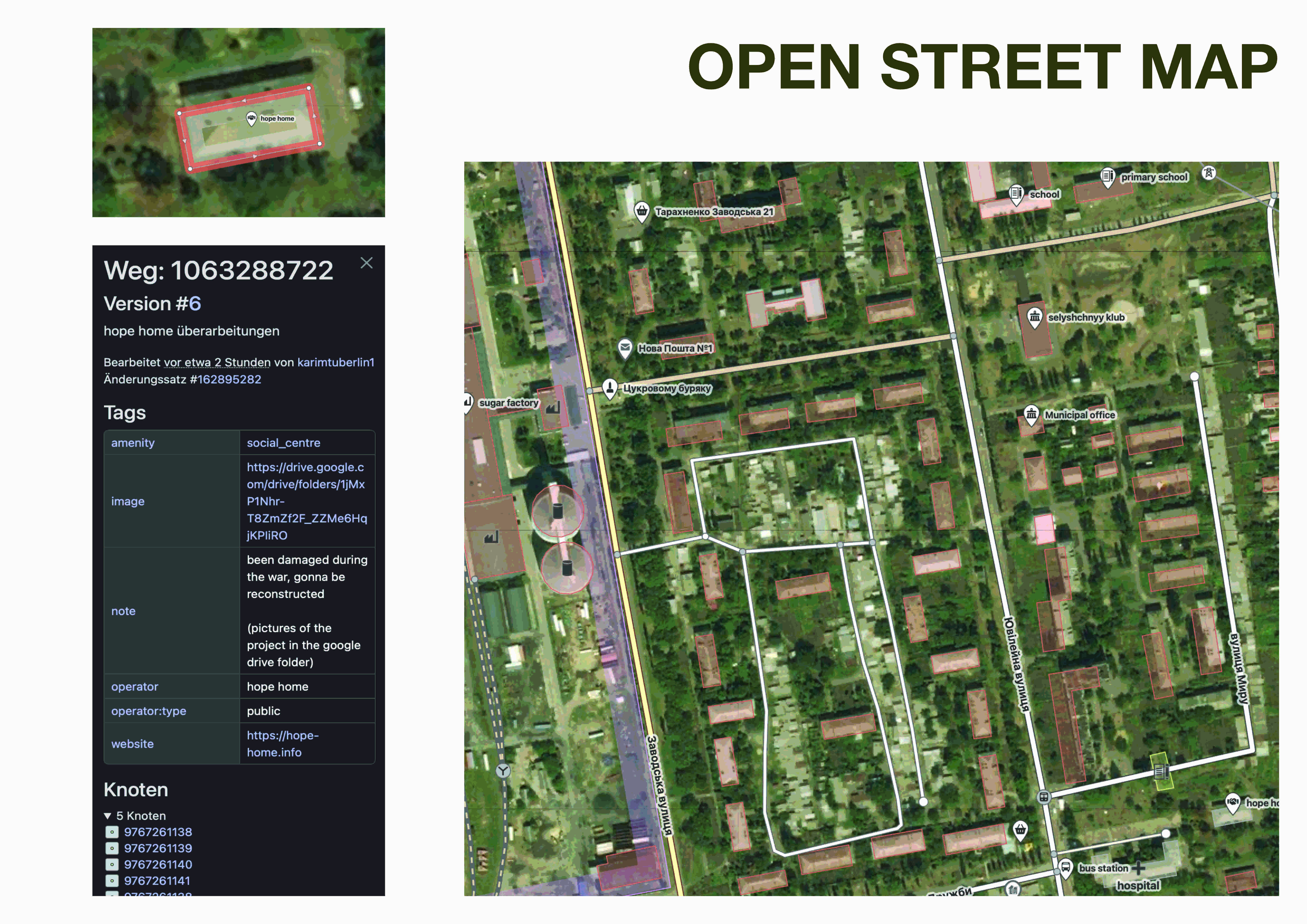
Guide: Retrieving Information in OpenStreetMap
To access stored information about a specific location in OpenStreetMap (OSM), users can either search for the city directly using the search bar on OpenStreetMap.org or open a specific link (https://www.openstreetmap.org/#map=14/47.04267/32.45653&layers=NDG) to the location. Once the map has loaded, objects such as streets, buildings, or points of interest (POIs) can be clicked to display detailed information, including names, addresses, opening hours, contact details, and other metadata, if available.
For a precise location query, users can right-click on a specific point on the map and select “What’s here?” to retrieve the exact coordinates of that location. If additional information is associated with the selected point, it will be displayed as well. Those interested in an object’s edit history can use the “View History” option to see all modifications made, along with the users who contributed to them.
Additionally, OpenStreetMap offers various map styles, accessible via the layers icon in the top-right corner. Users can choose from different views, including the standard map, a public transport map with bus and train lines, and a cycling map. These features provide a comprehensive and precise way to access geographic data.
Does Every OpenStreetMap User Need an Account?
Whether an OpenStreetMap account is necessary depends on the type of usage. Users who simply want to view maps, search for locations, or plan routes do not need an account. All essential features, such as retrieving street names, points of interest (POIs), or coordinates, are accessible without registration.
However, an account becomes necessary when users want to actively contribute to the map. This includes adding or modifying streets, buildings, and other map elements. A registered account also allows users to track their edits and interact with the OpenStreetMap community, such as by asking questions or participating in collaborative projects.
For basic navigation and map viewing, an account is not required. However, those looking to actively improve and maintain OpenStreetMap will benefit from the additional features a registered account provides.

